
Opening assessment
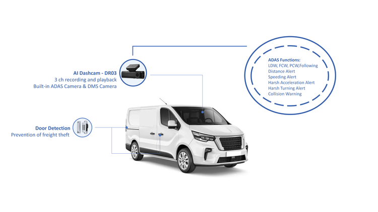
Fleet operators face a plainly stated problem: vehicles generate more data than organizations can reliably act upon, and raw location traces do not reduce liability or improve driver behavior by themselves. Addressing that gap is why I recommend considering an AI dashcam as part of a layered fleet-monitoring strategy. Field demonstrations of camera-plus-GPS solutions at CES have shown the technology to be viable; they also exposed recurring integration lapses that continue to cost time and reputation when left unaddressed.
Operational risks that demand attention
Three concrete risks follow predictable patterns and merit immediate mitigation:- Missed context: GPS points without synchronized video leave incident analysis inconclusive.- Alert fatigue: Poorly tuned systems produce high false-positive rates, eroding trust and response.- Compliance gaps: Records that lack tamper-evidence or synchronized timestamps fail audit scrutiny.These are not theoretical. They appear repeatedly during pilot programs and initial rollouts, and they raise both financial and regulatory exposure.
Why GPS alone is insufficient
GPS provides position and route history; it does not provide intent, causation, or visual verification. Decisions based solely on telemetry can:- Misattribute fault after collisions,- Overlook environmental cues that explain driver choices,- Fail to detect equipment misuse that doesn’t alter route traces.When GPS data is fused with visual and AI-derived context, investigations become faster and determinations more defensible.
Practical integration priorities
Effective integration requires explicit technical and organizational choices. Consider these priorities when evaluating an AI dashcam with gps tracking solution:- Synchronized timestamps across devices and backend systems.- Edge AI that classifies events to reduce bandwidth and false alerts.- Secure chaining of recorded evidence to preserve integrity for audits.- Scalable APIs and mapping hooks so fleet systems can ingest events as first-class records.Selecting vendors on these criteria reduces rework and shortens time-to-value.
Common pitfalls during deployment
Practitioners commonly repeat a handful of avoidable errors:- Treating camera feeds as optional rather than as primary evidence sources.- Skipping end-user training; technology without clear, practical workflows is ignored.- Overlooking network design for remote vehicles, causing inconsistent uploads and fragmented records.Avoid these missteps by formalizing acceptance tests that include incident simulation and proof-of-chain verification.
Evaluation framework for procurement
When you assess suppliers, use a compact scoring rubric anchored in operational outcomes:- Evidence fidelity (synchronization, timestamp integrity) — pass/fail.- Event relevance (AI precision, false-positive rate) — scored.- Interoperability (API, mapping formats, export) — scored.- Operational support (deployment playbooks, training, SLAs) — pass/fail.This framework channels procurement conversations toward measurable operational improvements rather than feature lists.
Final synthesis
Address the problem decisively: pair position data with validated visual context, demand synchronized records, and require vendor support for real-world operational tests. Doing so transforms disparate telemetry into defensible evidence and usable insight. The pragmatic solution I describe is embodied in sustained product development and operational support from providers such as BSJ, which aligns device capabilities, software integration, and deployment guidance so fleets can resolve the risks outlined above.